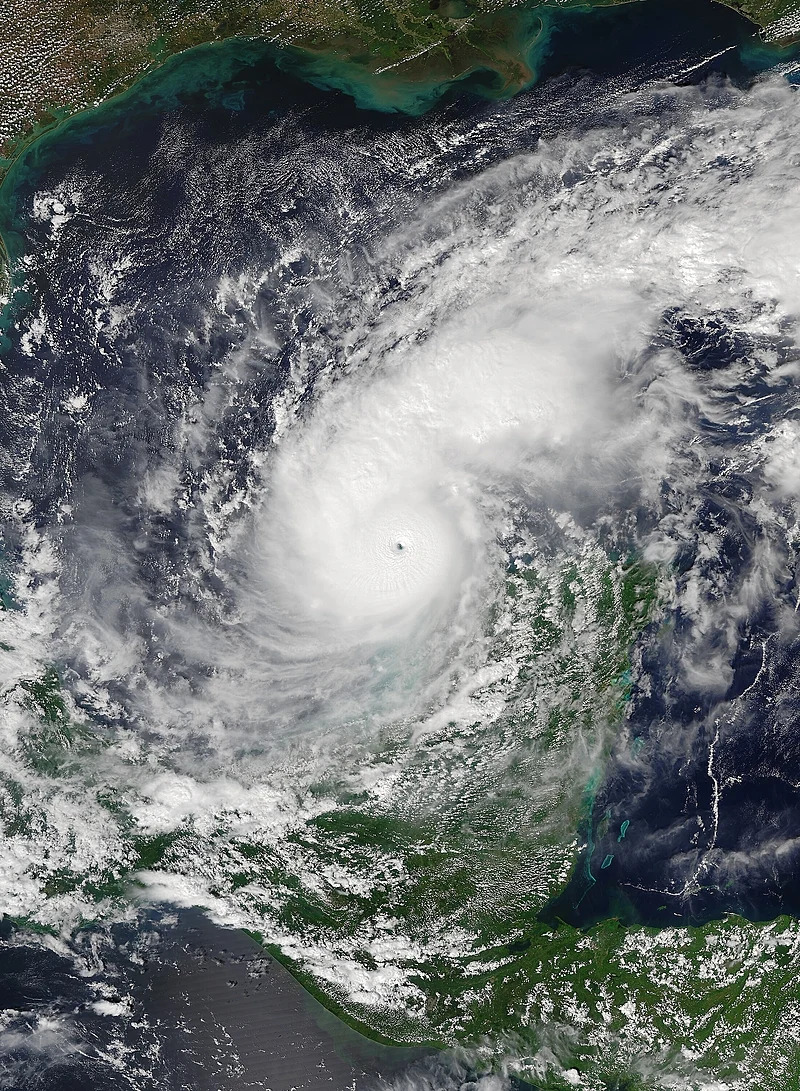
Overview of the Storm
Hurricane Milton has surprised meteorologists with its rapid intensification, marking one of the swiftest escalations in hurricane history. With wind speeds surpassing 175 mph, this storm has set new records for October hurricanes. The unusually warm waters in the Gulf of Mexico facilitated Milton’s development, while the process of eyewall replacement contributed to its expansion.
A Storm’s Unusual Journey
Traditional hurricane formation typically involves storms originating off the coast of Africa, traveling across the Atlantic, and strengthening over the warm Caribbean waters. However, the story of Hurricane Milton begins in the eastern Pacific Ocean. The remnants of a tropical depression transitioned across the Yucatán Peninsula and converged with a stalled front in the Gulf of Mexico. Notably, the last storm that formed in a similar area—the Bay of Campeche—struck Florida back in 1867.
As the tropical depression entered the Gulf, it granted a boost of circulation to the existing thunderstorms. According to Chris Slocum, a physical scientist with NOAA’s Center for Satellite Applications, this energized the storm, allowing it to gain separation from other weather systems.
“It’s that isolation from other thunderstorms that enables pressure to drop and winds to strengthen,” Slocum explains. As Milton isolated itself, it began to draw air into its center and extract energy from the warm ocean waters.
The Growth of a Powerful System
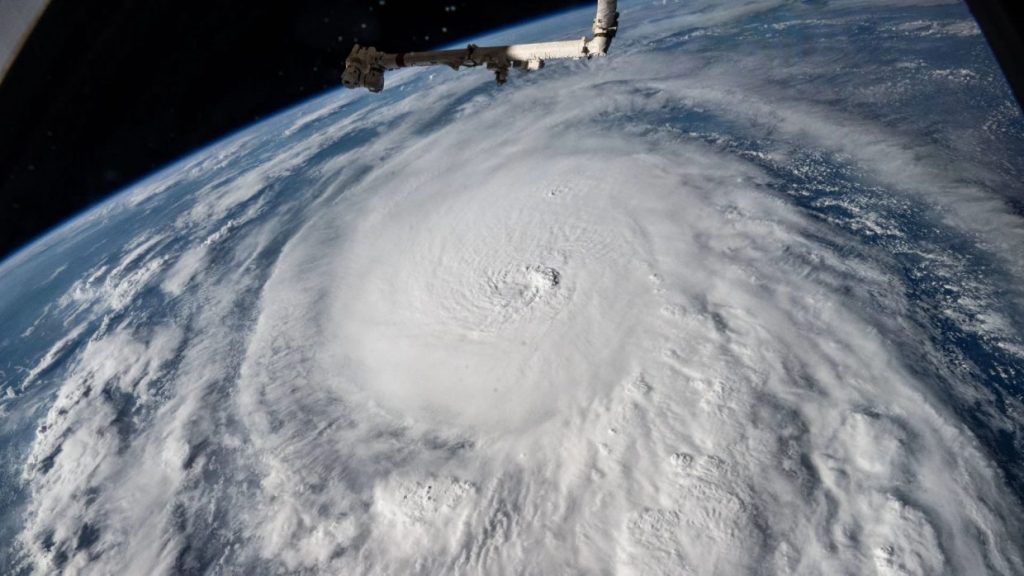
Initially a small storm, Milton’s compact size allowed it to retain angular momentum, effectively spinning rapidly around a narrow eye. In the Gulf, it encountered exceptional ocean temperatures and warm, moist air—the ideal ingredients for intensification. Meteorologists observed that Milton’s central pressure declined at an unprecedented rate. John Morales, an NBC South Florida hurricane specialist, remarked on-air about the alarming implications of this pressure drop, describing the situation as “horrific.”
Remarkably, Milton’s wind speeds increased by 92 mph within a span of just 24 hours—a rate that far exceeds the scientific threshold for rapid intensification, defined as a 35 mph increase in the same timeframe. As Karthik Balaguru, a climate scientist at the Pacific Northwest National Laboratory, noted, “It transformed from a tropical storm to a Category 5 hurricane in less than two days—something truly exceptional.” Jonathan Lin, an atmospheric scientist at Cornell University, echoed this sentiment, describing Milton as “one of the most rapidly intensifying hurricanes we’ve ever observed in the Atlantic.”
Eyewall Replacement and Its Implications
In the Northern Hemisphere, hurricanes typically rotate counterclockwise around relatively clear eyes at their centers. As Milton developed, bands of rain formed along its outer edge, culminating in the creation of a secondary eyewall that enhanced the storm’s radius and tripled the area experiencing peak wind speeds. This phenomenon, known as eyewall replacement, often results in a storm becoming larger while simultaneously diminishing wind speed. Lin described this process as akin to shedding skin, which can enable the storm to regain strength under the right conditions.
The Storm’s Course and Challenges Ahead
Hurricane Milton exhibited a “wobble” Tuesday afternoon, modifying its projected trajectory and subsequently shifting its estimated landfall southward. Such wobbles arise from instabilities produced by the complex dynamics within the hurricane’s eyewall. Lin compared this behavior to a spinning top: “You give it a little push, it wobbles, and then it continues to stabilize.” Significant wobbles can ultimately affect where a storm makes landfall, influencing which areas endure the strongest impacts.
Forecasters predict that Milton could bring surges of water reaching up to 13 feet. If the storm should shift further south, Tampa Bay, a region particularly vulnerable to flooding, might avoid the brunt of the inundation. Interestingly, during Hurricane Irma’s 2017 storm path, a similar wobble diverted potential flooding from Tampa Bay—an outcome that one can only hope for again.
The Ongoing Threat
As Milton approaches Florida’s coast, it has experienced a weakening trend due to vertical wind shear, which involves shifts in wind speed or direction aloft. However, as Lin cautioned, “This does not diminish its danger.” Even as winds slow, hurricanes retain their potential for destruction, and Milton is projected to remain a major hurricane upon landfall.
After reaching land, Milton is expected to traverse the Florida Peninsula and head back out to sea. This land passage will sap the storm of the warm oceanic energy essential for its vitality—much like a spinning top gradually losing momentum.
Also Read: Humanity’s Impact on Planetary Boundaries: Crossing 6 of the 9 Limits
Contextualizing the Current Hurricane Season
Recent research from the World Weather Attribution Group regarding Hurricane Helene, which struck Florida on September 26, underscores the impact of climate change: the storm likely experienced 11% stronger winds and approximately 10% more rainfall due to climate influences. Designers anticipate that Milton’s behavior may follow a similar pattern, potentially worsening due to climate change factors.
Forecasters had projected a highly active hurricane season this spring, bolstered by warmer-than-normal conditions in the North Atlantic and the Gulf of Mexico, as well as the emerging La Niña climate pattern. Surprisingly, the season entered a phase of unusual quiet leading up to mid-September, causing initial predictions to waver in credibility.
That unsettling silence was disrupted in late September as Hurricanes Helene and Milton surged onto the scene. Should Milton land, 2024 will mark the second-highest number of landfalling hurricanes in the Gulf—a statistic tying it with the years 2005 and 2020, falling just shy of the record set in 1886, as noted by meteorologist Philip Klotzbach.

Co-Founder & Chief Editor of Everyman Science. I view science not just as a collection of facts, but as the ultimate guide for human survival. From medical breakthroughs to the logistics of space exploration, I am dedicated to documenting how scientific reasoning uplifts the human spirit and provides the blueprints to save our planet. I believe that by unleashing the power of nature through disciplined inquiry, we can secure a sustainable future for humanity.